


Hike to the summit of Mount Pisgah off the Blue Ridge Parkway south of Asheville, climbing through a lush, green forest to beautiful views from a tower-capped mountaintop.
(round trip)
difficult
friendly
LOCATION:south of Asheville, NC on the Blue Ridge Parkway
PACK:our Osprey day pack and our hiking gear list
OFFICIAL MAP: Nat Geo 780 Trails Illustrated Map (find it at Trailful Outdoor Co.)
Mt Pisgah rises sharply from the National Forest that shares its name, easily visible from downtown Asheville on a clear day. And the mountain’s iconic, classic shape and towering television tower make the summit and easily visible from nearby mountaintops, like Fryingpan Mountain to the south. The mountain is rooted deeply in Asheville history, the former site of the Vanderbilt family’s Buck Springs Lodge, a hunting outpost southwest of the beloved Biltmore Estate.

The trail is one of the Asheville area’s most popular hikes, and for a good reason: the views from the summit’s observation deck are simply outstanding. While the hike is anything but easy (the second half is a nearly continuous, rocky climb to the Pisgah summit), it’s a relatively short hike, at just over 2 miles, round trip. The summit views are undoubtedly the main attraction, but the trail itself is well worth the hike: the trail climbs and meanders through a beautiful deciduous forest that fills with wildflowers in warm weather months.
In late spring to early summer, the forest explodes into bloom as gnarly-branched mountain laurel and rhododendron flare in abundant colorful blossoms. It’s one of the best classic hikes off the Blue Ridge Parkway near Asheville.

Mt Pisgah: the hike
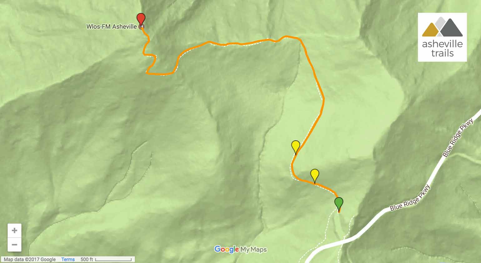
The hike departs from a signed parking area, located just off the Blue Ridge Parkway at MP 407.6 south of Asheville (view maps and driving directions). Views of the tower-capped mountain summit extend to the northwest from the trailhead, giving a preview of the climb ahead.
The trail meanders to the north, rising through a forest filled with wildflowers, tall grasses, vibrant green moss, leafy fern and lichen-crusted rock.

The trail arcs around the lower elevations of Little Pisgah Mountain, passing the .5 mile mark. The climb has been relatively gentle, until now, ascending scarcely 50 feet in the first half-mile. But the trail’s workout begins as the hike arcs westbound, veering due west toward Mt Pisgah and starting a nearly unrelenting climb to the summit. The trail climbs over rustic stone stairs and blocky rock outcrops as gains elevation.
The climb intensifies as the trail ascends an extended stretch of stone stairs at .95 mile and dives through a canopy of dense mountain laurel. The laurel’s gnarled, lichen-covered branches twist and turn, casting a dappled pattern of sunlight on the forest floor. The hike switches back, veering to the north in a final climb to the summit, and the pungent, onion-like smell of galax fills the air. (Need a break? A large outcrop sits just off the trail at 1.1 miles, offering a great pre-summit resting spot and a break from the climb.)

The trail reaches the Mt Pisgah summit at 1.15 miles. Abundant sunlight suddenly fills the trail as the hike ascends through the dense forest canopy to the sun-drenched peak. On the summit, a wooden observation deck offers far-flung views in nearly every direction, with views only partially obscured by the mountain’s massive, skyward-climbing tower. The views are spectacular.
Views extend northeast toward Asheville, west to Cold Mountain and south toward Fryingpan Mountain’s historic lookout tower and the rolling mountain balds at Black Balsam Knob and Tennent Mountain. The Blue Ridge Parkway is easily visible from the summit, winding and slicing through the mountainous landscape of the Pisgah National Forest.

Departing the summit, the hike retraces its outbound steps to the trailhead. The return hike is significantly easier, and nearly all downhill – and a great chance to soak in the forest’s lush beauty for the second time. The trail reaches the trailhead at 2.3 miles, completing the adventure.
More Blue Ridge Parkway hikes to view-packed summits
Up for another view-packed hike? Hike our top ten trails to the Blue Ridge Parkway’s best views near Asheville to score some truly incredible views.

Please Remember
Always leave no trace, pack out everything you pack in, and if you see trash, pick it up and pack it out.
Stay on the marked trail, tell someone where you're going, pack safety and wayfinding essentials, and don't rely on a mobile phone to find your way. Please always practice good trail etiquette. And before you go, always check the trailhead kiosk, official maps, and the park or ranger office for notices of changed routes, trail closures, safety information, and restrictions.
Mt Pisgah Trail Map, Directions & Details
Love the trail?
This trail is maintained thanks to the hard work of countless volunteers and donations from supporters of The Pisgah Conservancy. Please support them by making a donation or joining a volunteer day. Let's work together to keep these fantastic trails maintained and open for use!
Driving Directions
Parking
Free parking is available at the parking area, MP 407.6 on the Blue Ridge Parkway south of Asheville. (Before you go, check for trail updates and parkway closures on the official Blue Ridge Parkway website.)
GPS Coordinates
35.418833, -82.747900 // N35 25.130 w82 44.874
Elevation Profile


