Hike to incredible, wide panoramic views from the summit of Whiteside Mountain, and then take a challenging hike to the sheer-sided craggy tower at Devils Courthouse near Highlands, NC.
(round trip)
difficult
friendly
LOCATION:near Highlands, NC in the Nantahala National Forest
PACK:our Osprey day pack and our hiking gear list
OFFICIAL MAP: Nat Geo 785 Trails Illustrated Map (find it at Trailful Outdoor Co.)
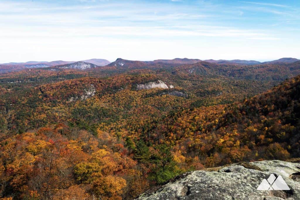
Stunning vistas and sheer mountain walls draw scores of weekend hikers to the outstanding loop trail at Whiteside Mountain. This enormous, rock-sided mountain is visible throughout the mountains and valleys surrounding Highlands, NC, and is well-loved as one of the area’s top hiking destinations. And while views from the lofty mountain are splendid, indeed, its popularity can be a bit overwhelming to experienced hikers looking to score some sublime views and some serenity. This hike follows the typical loop to Whiteside’s towering, sheer walls, and then diverts on a side trail to a nearby neighboring precipice, Devils Courthouse.
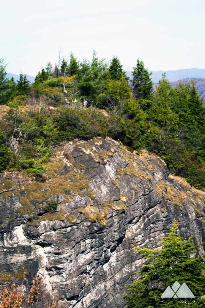
This hike is not at all beginner friendly: the trail to this towering rock spire is rugged, rooty, and rocky, and numerous side trails can easily cause confusion. But the views from Devils Courthouse are stunning, without the usual crowds at the Whiteside summit. Unlike the Whiteside overlooks, the Courthouse summit isn’t protected by cables or safety devices. But like Whiteside, the Courthouse dropoffs are sheer and sudden. Staying away from the edges is imperative: a fall from the Courthouse would easily be fatal, and many of the side trails along the way dead-end into sheer dropoffs.
(If you’re not a seasoned hiker with proper wayfinding tools, including printed maps, a compass, and a handheld GPS, or you have any doubts about your wayfinding ability or sure-footedness, or if you’re hiking with children, we absolutely do not recommend this hike. Check out the Whiteside Mountain Loop Trail instead. And definitely avoid this route on windy or storm-prone days, or if there’s a chance of lightning.)

Devils Courthouse: the hike
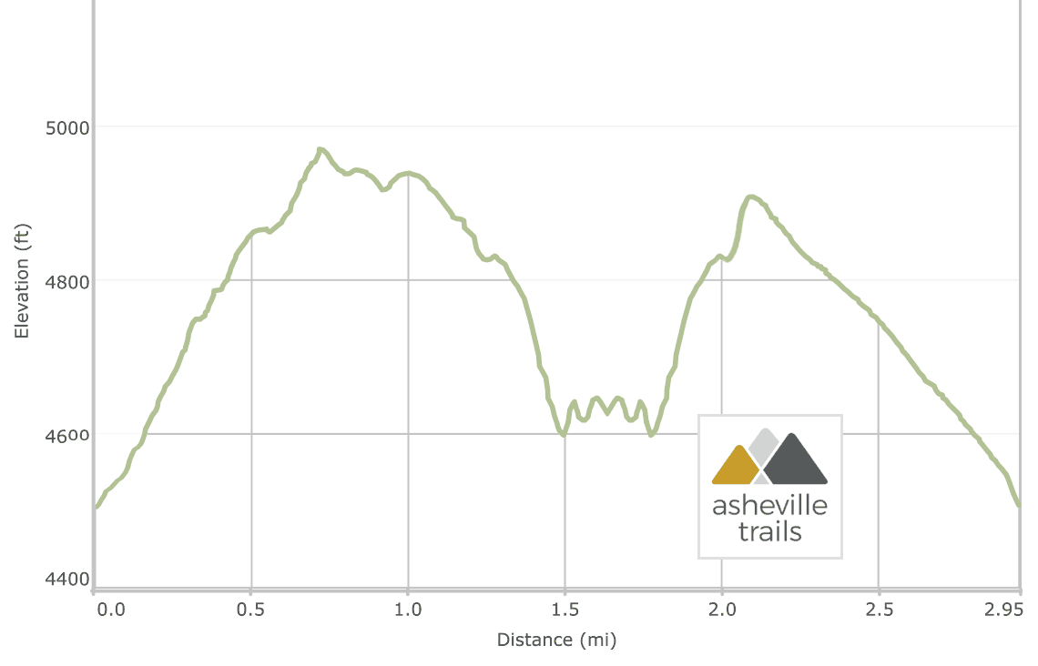
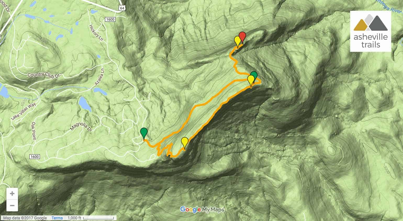
The adventure begins at the Whiteside Mountain trailhead near Highlands, NC (view maps and driving directions). The hike follows a wide gravel roadbed eastbound, and turns right at .1 mile to follow the Whiteside Loop in a counter-clockwise direction, following blue trail blazes. The trail ascends steadily, climbing through a forest filled with gnarly-branched rhododendron, climbing sets of metal and stone stairs, and passing a number of outstanding overlooks near the mountain’s soaring summit.
Cables border the steepest overlooks, where the mountain drops suddenly away. Whiteside’s towering cliffs drop in sheer dropoffs over 750 feet, making them the highest perpendicular bare rock faces on the East Coast.
The hike reaches the mountain’s summit at .75 miles, and then begins a steady decline. A number of overlooks offer outstanding views on the descent. Just before the trail arcs suddenly to the southwest, the hike reaches the unsigned trailhead to Devil’s Courthouse at just under 1.2 miles, to the right of the Chattooga Watershed overlook.
From here, the hike begins its most difficult and technical stretch, plunging through a rocky forest and tunneling through dense rhododendron.

The trail is rough and rugged, requiring scrambles over large angular boulders and climbs over large tree roots. A number of side trails spider off the main trail, leading to dead-ends and sudden drop-offs. This hike continues navigating along the main trail, dipping through the saddle and meandering through the dense forest toward the rocky spire ahead. (Again, do not attempt the route without an official printed topographic map and a handheld GPS.)
The hike begins a sudden ascent at 1.5 miles, climbing to a grassy, sun-drenched clearing on the summit of Devils Courthouse. Views extend from the summit from several expanses of open rock, but avoid coming even close to the edges: these elevations drop off immediately in a sheer freefall, and one wrong step could be deadly.
Departing the summit, the hike carefully retraces its outbound route along the Devils Courthouse Trail to the Whiteside Mountain Loop, reaching the Chattooga River Watershed overlook at just over 2 miles. On a clear day, the overlook offers a great view to the north, including Lake Glenville, and the towering Plott Balsam Mountain range on the far horizon, including Blackrock Mountain and The Pinnacle.
The hike picks up the Whiteside Mountain loop trail at the Chattooga River Watershed overlook, following a gravel road downhill from the clearing. It’s a nearly unrelenting descent to the trailhead, dropping through the rocky forest on Whiteside’s northwest slopes. The hike completes the loop at 2.8 miles, following the spur trail to the trailhead and parking area, and completing the adventure at just under 3 miles.

(There’s also a stone spire of the same name located off the Blue Ridge Parkway southwest of Asheville, with equally stunning views (and a much shorter and easier hike to the summit). Hike the Devils Courthouse Trail from the Parkway to stunning views into the mountains of Western NC as well as South Carolina, Georgia, and Tennessee.)
More top hikes near Highlands, NC
In the area with daylight and energy to spare? Check out our favorite hikes near Highlands and Cashiers for more of our favorite adventures in this high-elevation stretch of Western NC.

Please Remember
Always leave no trace, pack out everything you pack in, and if you see trash, pick it up and pack it out.
Stay on the marked trail, tell someone where you're going, pack safety and wayfinding essentials, and don't rely on a mobile phone to find your way. Please always practice good trail etiquette. And before you go, always check the trailhead kiosk, official maps, and the park or ranger office for notices of changed routes, trail closures, safety information, and restrictions.
Devils Courthouse at Whiteside Mountain Map, Directions & Details
Love the trail?
This trail is maintained thanks to the hard work of countless volunteers and donations from supporters of the National Forest Foundation. Please support them by making a donation or joining a volunteer day. Let's work together to keep these fantastic trails maintained and open for use!
Driving Directions
Parking
$2 per vehicle (cash) at the Whiteside Mountain Trailhead east of Highlands. Before you go, check for seasonal trail and road closures on the USFS Nantahala National Forest site.
GPS Coordinates
35.080417, -83.144033 // N35 04.825 W83 08.642
Elevation Profile