


Hike the Big Laurel Falls Trail to a gorgeous waterfall beneath abundant rhododendron in North Carolina’s Nantahala National Forest.
(round trip)
moderate
friendly
LOCATION:near Standing Indian Mountain and Franklin, NC
PACK:our Osprey day pack and our hiking gear list
OFFICIAL MAP: Nat Geo 785 Trails Illustrated Map (find it at Trailful Outdoor Co.)
Spilling over a blocky rock outcrop in the Nantahala National Forest, the headwaters of the Nantahala River cascade over Big Laurel Falls in a lush, green creek valley near the Appalachian Trail at Standing Indian Mountain. Spanning only a half mile in length, this hike packs in a ton of scenic beauty along its short stretch, following several boulder-filled creeks as they tumble and churn through a lush forest.

It’s not a long hike, at just over a mile, roundtrip – but it’s an incredibly beautiful one, especially in autumn, when the forest explodes into magnificent fall color. And with relatively moderate elevation gains, it’s a great hike for families and a must-visit for campers at the nearby Standing Indian Campground.

Big Laurel Falls: the hike
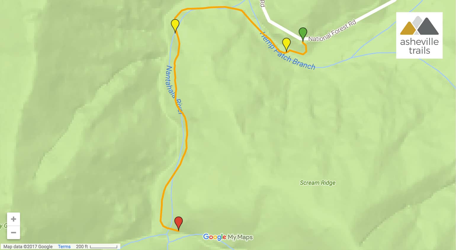
The hike begins at a trailhead located off the graveled Upper Nantahala Road (view maps and driving directions). The gravel road to the trailhead can be a bit of an adventure itself, but it’s particularly scenic in the golden hues of fall.
The hike veers westbound and follows a tumbling creek, Hemp Patch Branch, downstream. The stream drops in a series of shallow waterfalls, cascading over mossy boulders in the shady forest just upstream from a wooden bridge.

The trail crosses the wooden bridge, reaching a trail junction. From here, the Timber Ridge Trail turns east, hiking 2.3 miles to the Appalachian Trail near Carter Gap, west of the Albert Mountain, and east of Bly Gap and Standing Indian Mountain. This hike turns right at the junction, following the trail westbound. The trail ascends through dense thickets of rhododendron, colorful in every season thanks to the rhododendron’s leathery evergreen leaves and rust-colored, twisted, gnarly branches. The trail arcs southbound, following the tumbling creek upstream.
The sound of falling water echoes through the forest as the hike continues its ascent, rolling elevation southbound. The trail reaches the rocky, shallow pools below Big Laurel Falls at just over half a mile.

The waterfall tumbles over a blocky rock outcrop, spilling through the dense forest of rhododendron. The waterfall’s rocky basin makes a great mid-hike spot to grab a quick snack or drink and to admire the waterfall’s beauty.

Departing the waterfall, the hike turns to retrace its outbound steps to the trailhead, completing the hike at just over one mile.
Nearby summit-worthy hikes
This section of North Carolina’s Nantahala National Forest is full of fantastic, visit-worthy hikes. If you’re in the area and have extra energy to spare, hike the Appalachian Trail to the summit of Albert Mountain, and catch stunning summit views from the mountain’s historic fire lookout tower. Near the Appalachian Trail at Mooney Gap, the Pickens Nose Trail ascends a jagged, craggy mountain summit with spectacular overlook views. And the nearby AT hike to Standing Indian Mountain climbs through switchbacks and dense rhododendron tunnels to beautiful views from the mountain’s summit.
More waterfall adventures in Western NC
Up for chasing some more epic waterfall views, without a long, difficult hike? Our favorite hikes to Asheville waterfalls under two miles features some seriously stunning falls and scenic forest views, and many hikes under a mile, too.

Please Remember
Always leave no trace, pack out everything you pack in, and if you see trash, pick it up and pack it out.
Stay on the marked trail, tell someone where you're going, pack safety and wayfinding essentials, and don't rely on a mobile phone to find your way. Please always practice good trail etiquette. And before you go, always check the trailhead kiosk, official maps, and the park or ranger office for notices of changed routes, trail closures, safety information, and restrictions.
Big Laurel Falls Trail Map, Directions & Details
Love the trail?
This trail is maintained thanks to the hard work of countless volunteers and donations from supporters of the National Forest Foundation. Please support them by making a donation or joining a volunteer day. Let's work together to keep these fantastic trails maintained and open for use!
Driving Directions
Parking
Free parking is available at the trailhead. Trailhead access is via gravel Forest Service roads. Before you go, check for seasonal trail and road closures on the USFS Nantahala National Forest site.
GPS Coordinates
35.022000, -83.503567 // N35 01.320 W83 30.214
Elevation Profile


