Hike to expansive views of the Chimney Tops pinnacle and Mount LeConte on a spectacular adventure in Great Smoky Mountains National Park.
(round trip)
difficult
allowed
LOCATION:in Great Smoky Mountains National Park
PACK:our Osprey day pack and our hiking gear list
OFFICIAL MAP: Trails Illustrated #317: Clingmans Dome, Cataloochee, Great Smoky Mountains National Park (find it at Trailful Outdoor Co.)
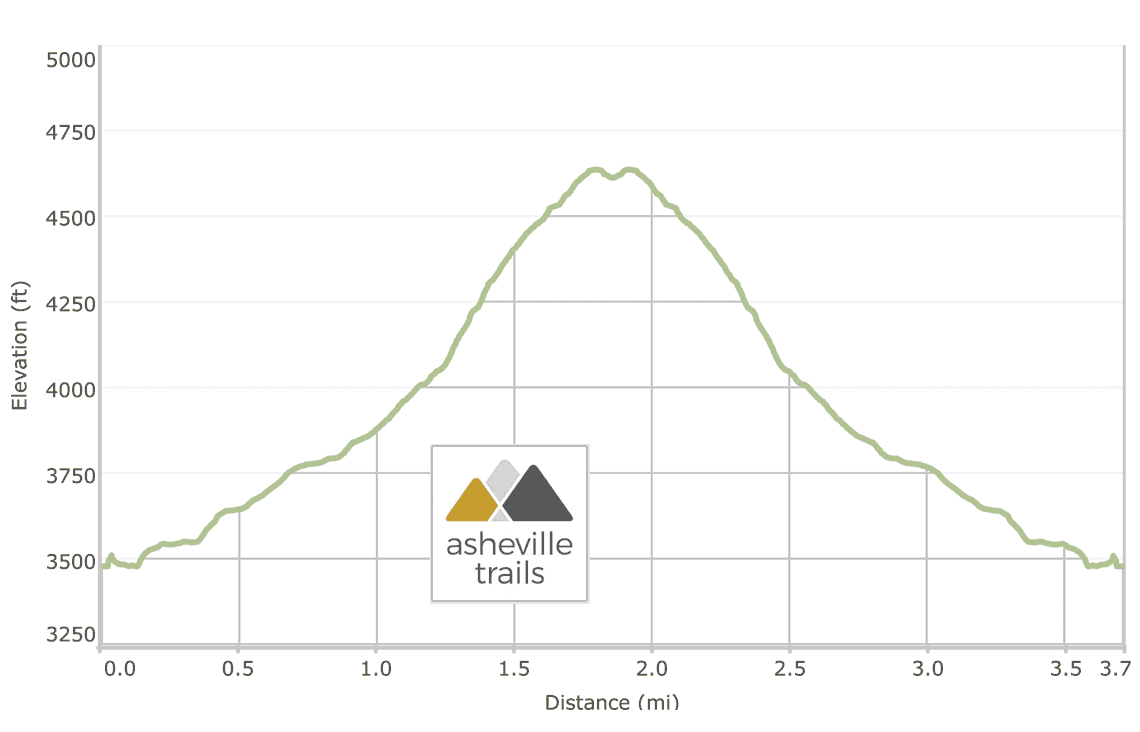
Chimney Tops is one of the most sought-after and outstanding vistas in the Great Smoky Mountains National Park. The hike to this craggy pinnacle is located minutes from Gatlinburg and a stone’s throw from the towering summit of Mount LeConte. It’s a strenuous out-and-back hike that’s notorious for making hikers earn the coveted view from the summit. Though it’s difficult, this is a relatively short hike, spanning under four miles, round trip. And though the trail takes ample effort, it entirely makes up for in beauty.
Unfortunately, in 2016, a wildfire scorched over 10,000 acres of surrounding forest and condemned access to the true summit of Chimney Tops. After the wildfire damage, a potent mixture of seasonally heavy rains and a propensity for mudslides along this narrow ridge are cause for concern. Thus, the complete hike to the pinnacle is closed indefinitely. But there’s still ample beauty to be found on this hike, even though it no longer climbs to the actual summit – and the views are pretty sublime.


Chimney Tops: the hike
The adventure begins at a trailhead just off Route 441, southeast of Gatlinburg (view maps and driving directions). The trailhead is well marked, but parking is limited; arrive early start to ensure a parking spot in peak season.

The hike departs in a southerly direction, making a quick descent over stone staircases. The trail quickly crosses the first of four bridges along this route, following the bridge across the astonishingly clear West Prong of the Little Pigeon River. The trail arcs to the southwest, leading to the second bridge crossing, this time over the Road Prong. The trail veers through a hairpin turn, beginning an uphill assault. The climb starts modestly at first, but a healthy number of stairs and straight inclines await.
The Chimney Tops Trail continues its southeast journey, crossing the third bridge at a third of a mile. Below the bridge, Road Prong cascades in small chutes of whitewater and waterfalls, well worth a stop to admire.

The trail soon begins a sharp climb, gaining over 1000 vertical feet in the next mile and a half. The stream’s volume begins to dwindle as the hike continues its ascent and breaths inevitably become short and shallow. After making the fourth creek crossing at just under a mile, the hike reaches a trail intersection. From there, the Road Prong Trail continues along its namesake stream to several waterfalls and the Appalachian Trail near Newfound Gap. This route veers to the northwest, continuing to follow the Chimney Tops Trail and ascending steadily.

At 1.5 miles, the trail reaches a ridge line, veering roughly to the north and following a series of switchbacks as it climbs to the trail’s new observation point. The trail passes under a tunnel of pine, oak, spruce, and rhododendron. (At first glance it appears that the trail continues along the ridge to the north – however, a quick jaunt around the corner unveils a dead-end and wire-framed gate. This section is closed for the foreseeable future.)

The view from the lookout is astoundingly beautiful, with almost 180 degrees of clear views. Chimney Tops is visible to the north, and Mount LeConte and the Alum Cave Bluffs lie to the east. The views are particularly beautiful in spring and summer, when a plethora of rhododendron and wildflowers are in full bloom.
After taking in the view, the hike turns to follow the outbound route in reverse. The return route is almost entirely downhill, following a steep descent to the trailhead. (Descending this steep terrain can be hazardous, especially when the terrain is wet. Tread carefully, and remember to yield to the uphill hikers as they climb!) The hike reaches the trailhead at 3.7 miles, completing the adventure.
Nearby adventures in the Smokies
In the area with some energy left to burn? Follow one of the most outstanding hikes in the Smoky Mountains nearby, hiking the Alum Cave Trail to Mt LeConte. This twelve-mile adventure visits the view-packed summit of LeConte and explores the Alum Cave Bluffs, Arch Rock, and Gracie’s Pulpit along the route. Follow the Trillium Gap Trail to Grotto Falls, a beautiful walk-behind waterfall located off the Roaring Fork Motor Nature Trail near Gatlinburg. Hike the Forney Ridge Trail to Andrews Bald, exploring a sun-drenched, grassy summit near the craggy heights of Clingman’s Dome. Or check out the full list of our favorite hikes in the Smoky Mountains for even more adventure inspiration.

Please Remember
Always leave no trace, pack out everything you pack in, and if you see trash, pick it up and pack it out.
Stay on the marked trail, tell someone where you're going, pack safety and wayfinding essentials, and don't rely on a mobile phone to find your way. Please always practice good trail etiquette. And before you go, always check the trailhead kiosk, official maps, and the park or ranger office for notices of changed routes, trail closures, safety information, and restrictions.
Chimney Tops Trail Map, Directions & Details

Love the trail?
This trail is maintained thanks to the hard work of countless volunteers and donations from supporters of the Friends of the Smokies. Please support them by making a donation or joining a volunteer day. Let's work together to keep these fantastic trails maintained and open for use!
Driving Directions
Parking
Free parking is available at the trailhead.
GPS Coordinates
35.635567, -83.469583 // N35 38.134 W83 28.175
Elevation Profile